Lakestarr-Santa complex, 15 to 30 percent slopes
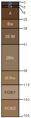
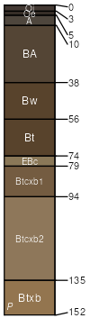
Lakestarr
(40%)
Ashy Mountains and Valleys 30-45 PZ Frigid Western Bitterroot Foothills
Andic Hapludalfs
Moderately well drained
Hydric: No
PAWS: 26 cm
mountains
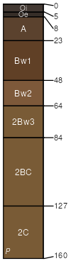
Santa
(25%)
Fragipan Foothills 24-30 PZ Frigid Eastern Columbia Plateau Embayments
Vitrandic Fragixeralfs
Moderately well drained
Hydric: No
PAWS: 16 cm
mountain slopes
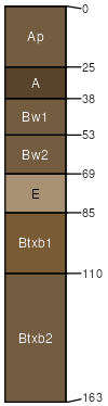
Kruse
(10%)
Vitrandic Haploxeralfs
Well drained
Hydric: No
PAWS: 22 cm
mountain slopes
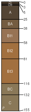
Keeler
(10%)
Vitrandic Hapludalfs
Well drained
Hydric: No
PAWS: 16 cm
mountain slopes
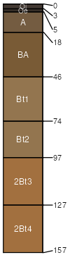
Taney
(5%)
Vitrandic Argixerolls
Moderately well drained
Hydric: No
PAWS: 18 cm
plateaus
loess hills / Summit
loess hills / Backslope
Lakestarr
(5%)
Andic Hapludalfs
Moderately well drained
Hydric: No
PAWS: 26 cm
mountain slopes
Bouldercreek
(5%)
Typic Udivitrands
Well drained
Hydric: No
PAWS: 17 cm
mountain slopes
SSA
Scale
Published
Export
wa063
1:24,000
2012
2025-08-28