Irigul-Caseypeak-Rock outcrop complex, 10 to 70 percent slopes
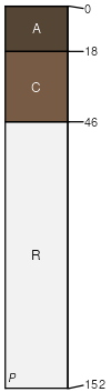
Irigul
(40%)
Shallow Igneous (SwIg) 15-19 Foothills and Mountains East Precipitation Zone
Lithic Haplocryolls
Well drained
Hydric: No
PAWS: 4 cm
mountains
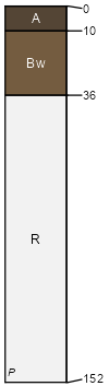
Caseypeak
(30%)
Igneous (Ig) 15-19 Foothills and Mountains East Precipitation Zone
Lithic Haplocryepts
Well drained
Hydric: No
PAWS: 3 cm
mountains
Rock outcrop
(20%)
Hydric: No
PAWS: NA
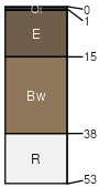
Hechtman
(10%)
Lithic Haplocryepts
Well drained
Hydric: No
PAWS: 2 cm
mountains
SSA
Scale
Published
Export
wy647
1:24,000
2025-09-04