Chittum-Bachus-Rock outcrop complex, 2 to 25 percent slopes
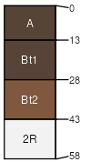
Chittum
(35%)
Shallow Loamy (SwLy) 15-19 Foothills and Mountains East Precipitation Zone
Lithic Argicryolls
Well drained
Hydric: No
PAWS: 4 cm
hillslopes
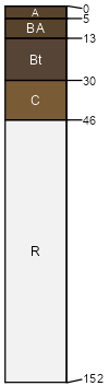
Bachus
(30%)
Loamy (Ly) 15-19 Foothills and Mountains East Precipitation Zone
Pachic Argicryolls
Well drained
Hydric: No
PAWS: 10 cm
hillslopes
Rock outcrop
(15%)
Hydric: No
PAWS: NA
Mosroc
(7%)
Shallow Igneous Foothills and Basins West (SwIg)
Lithic Argicryolls
Well drained
Hydric: No
PAWS: 4 cm
hillslopes
Decross
(7%)
Loamy (Ly) 15-19 Foothills and Mountains East Precipitation Zone
Calcic Pachic Argicryolls
Well drained
Hydric: No
PAWS: 28 cm
mountain slopes
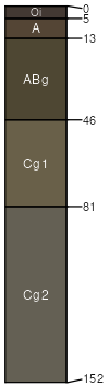
Venapass
(6%)
Wetland High Plains Southeast (WL)
Typic Cryaquolls
Poorly drained
Hydric: Yes
PAWS: 18 cm
flood plains
SSA
Scale
Published
Export
wy647
1:24,000
2025-09-04