Lymanson-Cheadle-Adel, complex, 8 to 35 percent slopes
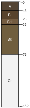
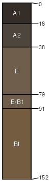
Lymanson
(40%)
Upland Sagebrush Shrubland Group
Ustic Argicryolls
Well drained
Hydric: No
PAWS: 12 cm
mountains / Backslope
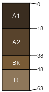
Cheadle
(30%)
Shallow Sagebrush Shrubland Group
Lithic Haplocryolls
Well drained
Hydric: No
PAWS: 3 cm
mountains / Summit
mountains / Shoulder
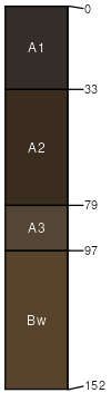
Adel
(20%)
Upland Sagebrush Shrubland Group
Pachic Haplocryolls
Well drained
Hydric: No
PAWS: 26 cm
mountains
swales
Bridger
(4%)
Upland Grassland Group
Ustic Argicryolls
Well drained
Hydric: No
PAWS: 21 cm
mountains / Footslope
mountains / Toeslope
Pintlar
(4%)
Upland Grassland Group
Ustic Palecryolls
Well drained
Hydric: No
PAWS: 21 cm
mountains
swales
Gilispie
(2%)
Shallow Shrubland Group
Lithic Argicryolls
Well drained
Hydric: No
PAWS: 5 cm
mountains / Summit
mountains / Shoulder
SSA
Scale
Published
Export
mt669
1:24,000
2025-09-03