Kounter-Rock outcrop complex, 15 to 45 percent slopes
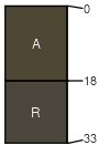
Kounter
(50%)
Shallow Grassland Group
Aridic Lithic Haplustepts
Somewhat excessively drained
Hydric: No
PAWS: 2 cm
hills
Rock outcrop
(35%)
Hydric: Unranked
PAWS: NA
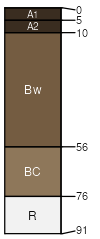
Zbart
(7%)
Shallow Shrubland Group
Aridic Lithic Ustorthents
Somewhat excessively drained
Hydric:
PAWS: 1 cm
hillsides
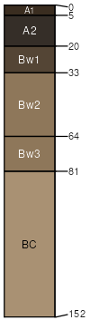
Branham
(7%)
Upland Sagebrush Shrubland
Ustic Haplocryolls
Well drained
Hydric: No
PAWS: 5 cm
hillsides
Tibkey
(1%)
Subirrigated Shrubland Group
Fluvaquentic Haplocryolls
Somewhat poorly drained
Hydric: No
PAWS: 17 cm
drainageways
SSA
Scale
Published
Export
mt604
1:24,000
2001
2025-08-30