Catto-Buckear-Rock outcrop complex, 20 to 60 percent slopes
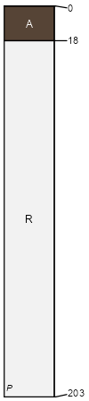
Catto
(50%)
Chert Hill, Desert Grassland
Lithic Ustic Torriorthents
Well drained
Hydric: No
PAWS: 1 cm
ridges / Summit
ridges / Shoulder
ridges / Backslope
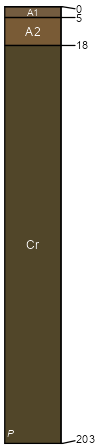
Buckear
(34%)
Sandstone Hill and Mountain, Desert Grassland
Ustic Torriorthents
Well drained
Hydric: No
PAWS: 2 cm
ridges / Footslope
Rock outcrop
(11%)
Hydric: No
PAWS: NA
ridges
hillslopes
ridges
mountains
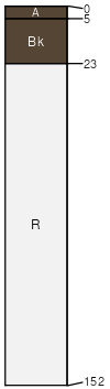
Bissett
(5%)
Limestone Hill and Mountain, Desert Grassland
Well drained
Hydric: No
PAWS: NA
SSA
Scale
Published
Export
tx622
1:32,000
1998
2025-09-05