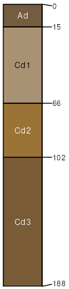
Latimer silt loam, 0 to 2 percent slopes, occasionally flooded
Latimer
(100%)
Mined Land
Alfic Udarents
Well drained
Hydric: No
PAWS: 21 cm
SSA
Scale
Published
Export
ok061
1:24,000
1972
2025-08-29