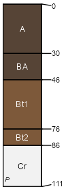
Eram (55%)
Clayey Upland
Aquic Argiudolls
Moderately well drained
Hydric: No
PAWS: 16 cm |

|
|
|
Bates (3%)
Loamy Upland
Typic Argiudolls
Well drained
Hydric: No
PAWS: 13 cm |

|
|
Taloka (3%)
Claypan Upland
Mollic Albaqualfs
Somewhat poorly drained
Hydric: No
PAWS: 31 cm |

|
|
Wynona (2%)
Wet Floodplain
Cumulic Epiaquolls
Somewhat poorly drained
Hydric: Yes
PAWS: 38 cm |

|
|
Dennis (2%)
Loamy Upland
Aquic Argiudolls
Somewhat poorly drained
Hydric: No
PAWS: 35 cm |

hillslopes / Backslope hillslopes / Shoulder
|
|