Bismarck (40%)
Shallow Upland
Typic Dystrudepts
Somewhat excessively drained
Hydric: No
PAWS: 4 cm |
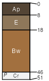
hills / Summit hills / Backslope
|
|
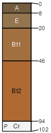
Nashoba (35%)
Loamy Upland
Typic Dystrudepts
Well drained
Hydric: No
PAWS: 7 cm |

hills / Summit hills / Backslope
|
|
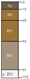
Sherless (15%)
Loamy Upland
Typic Hapludults
Well drained
Hydric: No
PAWS: 15 cm |
hillslopes / Shoulder hillslopes / Backslope
|
|
Clebit (5%)
Shallow Upland
Lithic Dystrudepts
Well drained
Hydric: No
PAWS: 2 cm |

mountains / Summit mountains / Shoulder
|
|
Mazarn (5%)
Drainageway
Aquic Hapludults
Somewhat poorly drained
Hydric: No
PAWS: 16 cm |
open depressions / Toeslope
|
|