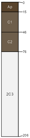
Sparham clay loam, 0 to 3 percent slopes
Sparham
(85%)
Clayey Bottomland
Typic Ustifluvents
Well drained
Hydric: No
PAWS: 23 cm
flood plains / Toeslope
Walrees
(5%)
Riverine Riparian
Aquic Ustifluvents
Somewhat poorly drained
Hydric: No
PAWS: 14 cm
swales / Toeslope
Werlog
(5%)
Salty Bottomland
Aquic Ustifluvents
Somewhat poorly drained
Hydric: No
PAWS: 24 cm
flood plains / Toeslope
Alcalde
(5%)
Clayey
Vertic Torriorthents
Well drained
Hydric: No
PAWS: 12 cm
stream terraces / Toeslope
SSA
Scale
Published
Export
nm650
1:24,000
1989
2025-09-09