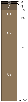
Far-Hogris association, 15 to 60 percent slopes
Far
(55%)
Shallow Hills 20-23 p.z. (QUEM, QUAR, JUDE2)
Lithic Haplustolls
Well drained
Hydric: No
PAWS: 3 cm
mountains / Summit
hills / Summit
Hogris
(25%)
Loamy Hills 20-23 p.z. (QUAR, QUEM)
Typic Ustorthents
Somewhat excessively drained
Hydric: No
PAWS: 6 cm
hills / Summit
mountains / Summit
Unnamed soils
(20%)
Hydric: No
PAWS: NA
SSA
Scale
Published
Export
az671
1:24,000
2000
2025-08-27