Splanod-Rock outcrop complex, 2 to 15 percent slopes
Splanod
(41%)
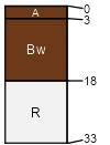
Sandy Loam Hills 10-13 p.z. Limy, Shallow
Lithic Torriorthents
Well drained
Hydric: No
PAWS: 2 cm
mesas / Summit
plateaus / Summit
Rock outcrop
(40%)
Hydric: No
PAWS: NA
Unnamed soils
(19%)
Hydric: No
PAWS: NA
SSA
Scale
Published
Export
az699
1:24,000
1993
2025-08-27