Lampshire-Pantak-Rock outcrop complex, 25 to 60 percent slopes
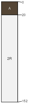
Lampshire
(40%)
Shallow Hills 12-16 p.z.
Lithic Ustic Torriorthents
Well drained
Hydric: No
PAWS: 2 cm
mountains / Summit
hills / Summit
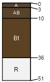
Pantak
(30%)
Shallow Hills 12-16 p.z.
Lithic Ustic Haplargids
Well drained
Hydric: No
PAWS: 1 cm
mountains / Summit
hills / Summit
Rock outcrop
(20%)
Hydric: No
PAWS: NA
Unnamed soils
(10%)
Hydric: No
PAWS: NA
SSA
Scale
Published
Export
az669
1:24,000
1993
2025-08-27