Wrays-Gilwood silt loams, 6 to 20 percent slopes
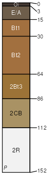
Wrays
(45%)
Deep Well Drained Siltstone-Shale Uplands
Typic Hapludults
Well drained
Hydric: No
PAWS: 17 cm
hills / Shoulder
hills / Backslope
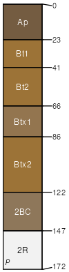
Gilwood
(35%)
Moderately Deep Siltstone-Shale Uplands
Typic Hapludults
Well drained
Hydric: No
PAWS: 9 cm
hills / Backslope
hills / Shoulder
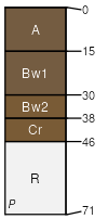
Spickert
(10%)
Fragipan Uplands
Typic Fragiudults
Moderately well drained
Hydric: No
PAWS: 22 cm
hills / Backslope
hills / Shoulder
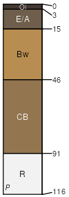
Brownstown
(10%)
Moderately Deep Siltstone-Shale Uplands
Typic Dystrudepts
Well drained
Hydric: No
PAWS: 8 cm
hills / Backslope
SSA
Scale
Published
Export
in105
1:16,000
1979
2025-09-03