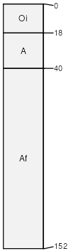
Copper River peat, 12 to 20 percent slopes
Copper River
(90%)
Glaciolacustrine Uplands, Ruptic
Typic Histoturbels
Very poorly drained
Hydric: Yes
PAWS: 10 cm
stream terraces
lake plains
till plains
hills
Better drained soils
(6%)
Somewhat poorly drained
Hydric: No
PAWS: 10 cm
till plains
lake plains
stream terraces
hills
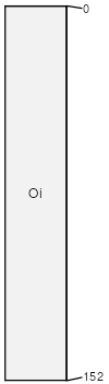
Histosols
(4%)
Very poorly drained
Hydric: Yes
PAWS: 52 cm
depressions
SSA
Scale
Published
Export
ak612
1:24,000
1991
2025-08-29