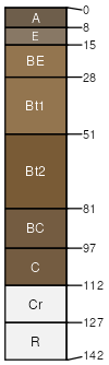
Westmoreland silt loam, 15 to 25 percent slopes, severely eroded
Westmoreland
(80%)
Side Slope
Ultic Hapludalfs
Well drained
Hydric: No
PAWS: 21 cm
benches / Backslope
ridges / Summit
SSA
Scale
Published
Export
wv611
1:20,000
1977
2025-09-08