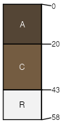
Hazton-Rock outcrop complex, 10 to 40 percent slopes
Hazton
(45%)
Shallow Igneous (Foothills And Mountains Southeast)
Lithic Haplocryolls
Well drained
Hydric: No
PAWS: 2 cm
mountain slopes / Backslope
mountain slopes / Summit
Rock outcrop
(40%)
Hydric: No
PAWS: NA
mountain slopes / Backslope
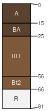
Kezar
(10%)
Loamy (Foothills And Mountains Southeast)
Ustic Argicryolls
Well drained
Hydric: No
PAWS: 7 cm
mountain slopes / Backslope
mountain slopes / Footslope
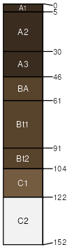
Clayburn
(5%)
Loamy (Ly) 15-19 Foothills and Mountains East Precipitation Zone
Pachic Argicryolls
Well drained
Hydric: No
PAWS: 27 cm
mountain slopes / Footslope
SSA
Scale
Published
Export
wy625
1:24,000
1985
2025-09-04