Cushool-Worfstone sandy loams, 2 to 15 percent slopes
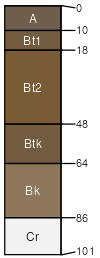
Cushool
(45%)
Sandy High Plains Southeast (Sy)
Ustic Haplargids
Well drained
Hydric: No
PAWS: 10 cm
hills
ridges
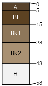
Worfstone
(40%)
Very Shallow High Plains Southeast (VS)
Borollic Lithic Haplargids
Well drained
Hydric: No
PAWS: 3 cm
hills
ridges
Alcova sl
(10%)
Hydric: No
PAWS: NA
Rock River sl
(5%)
Hydric: No
PAWS: NA
SSA
Scale
Published
Export
wy625
1:24,000
1985
2025-09-04