Pilotpeak-Canwall complex, 3 to 20 percent slopes
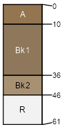
Pilotpeak
(55%)
Very Shallow High Plains Southeast (VS)
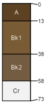
Lithic Ustic Haplocalcids
Well drained
Hydric: No
PAWS: 3 cm
cuestas
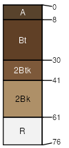
Canwall
(25%)
Shallow Sandy High Plains Southeast (SwSy)
Ustic Calciargids
Well drained
Hydric: No
PAWS: 5 cm
dip slopes
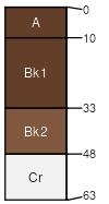
Tieside
(6%)
Ustic Haplocalcids
Well drained
Hydric: No
PAWS: 6 cm
dip slopes
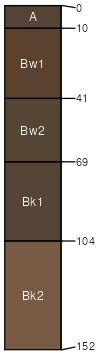
Telecan
(6%)
Cumulic Haplustolls
Well drained
Hydric: No
PAWS: 21 cm
drainageways
dip slopes
Bruja
(6%)
Ustic Haplocalcids
Well drained
Hydric: No
PAWS: 3 cm
dip slopes
Rock outcrop
(2%)
Hydric: Unranked
PAWS: NA
dip slopes
SSA
Scale
Published
Export
wy601
1:24,000
1991
2025-09-04