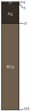
Irim loam, 0 to 1 percent slopes
Irim
(85%)
Mountain Meadow Gunnison Basin LRU
Typic Haplaquolls
Poorly drained
Hydric: Yes
PAWS: 15 cm
streams
drainageways
flood plains
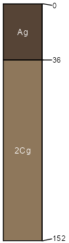
Alluvial land
(5%)
Well drained
Hydric: No
PAWS: NA
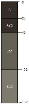
Big Blue
(5%)
Poorly drained
Hydric: Yes
PAWS: NA
depressions
Gas Creek
(5%)
Poorly drained
Hydric: Yes
PAWS: NA
flood plains
SSA
Scale
Published
Export
co662
1:24,000
1968
2025-09-02