Longcreek-Devada-Rubble land complex, 30 to 50 percent slopes
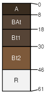
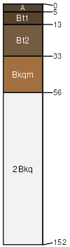
Longcreek
(35%)
STONY LOAM 9-12
Lithic Argixerolls
Well drained
Hydric: No
PAWS: 4 cm
mountains / Backslope
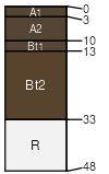
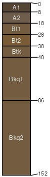
Devada
(30%)
SHALLOW STONY LOAM 9-12
Lithic Argixerolls
Well drained
Hydric: No
PAWS: 4 cm
mountains / Shoulder
Rubble land
(20%)
Excessively drained
Hydric: No
PAWS: 8 cm
mountains / Backslope
Brubeck
(4%)
CLAY UPLAND 9-16
Aridic Haploxererts
Well drained
Hydric: No
PAWS: 12 cm
plateaus
Horsecamp
(4%)
CLAY UPLAND 9-16
Aridic Haploxererts
Well drained
Hydric: No
PAWS: 16 cm
plateaus
Shinnpeak
(4%)
VERY SHALLOW STONY LOAM 9-12
Xeric Argidurids
Well drained
Hydric: No
PAWS: 3 cm
fan remnants
Cleghorn
(3%)
LOAMY UPLAND 9-12
Durinodic Xeric Haplargids
Well drained
Hydric: No
PAWS: 20 cm
fan remnants
SSA
Scale
Published
Export
ca608
1:24,000
2000
2025-09-03