Shasta-Washougal families-Washougal family, deep association, 0 to 30 percent slopes.
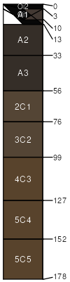
Shasta family
(40%)
Mesic Lava Plateaus, Low Sloping (15% or less), <25 inch precip
Umbric Vitrandepts
Well drained
Hydric: No
PAWS: 15 cm
mudflows / Footslope
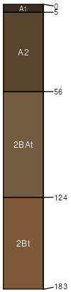
Washougal family
(30%)
Mesic Lava Plateaus, Low Sloping (15% or less), <25 inch precip
Andic Xerumbrepts
Well drained
Hydric: No
PAWS: 6 cm
lava flows / Backslope
Washougal family
(20%)
Mesic Ash-Influenced Mountains
Andic Xerumbrepts
Well drained
Hydric: No
PAWS: 11 cm
outwash terraces / Toeslope
Germany family
(5%)
Hydric: No
PAWS: NA
Germany family
(5%)
Hydric: No
PAWS: NA
SSA
Scale
Published
Export
ca707
1:24,000
1983
2025-09-03