Lang-Urban land complex, drained, 0 to 2 percent slopes
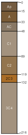
Lang
(55%)
Stream Channels and Floodplains
Typic Psammaquents
Moderately well drained
Hydric: Yes
PAWS: 13 cm
flood-plain splays
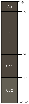
Urban land
(30%)
Hydric: No
PAWS: 0 cm
flood-plain splays
Columbia
(8%)
Hydric: Yes
PAWS: NA
natural levees
flood-plain splays
Egbert
(7%)
Hydric: Yes
PAWS: NA
backswamps
SSA
Scale
Published
Export
ca067
1:24,000
1989
2025-09-02