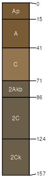
Columbia sandy loam, drained, 0 to 2 percent slopes, occasionall y flooded
Columbia
(85%)
Stream Channels and Floodplains
Aquic Xerofluvents
Somewhat poorly drained
Hydric: Yes
PAWS: 15 cm
flood plains / Toeslope
Cosumnes
(3%)
Stream Channels and Floodplains
Hydric: Yes
PAWS: NA
flood plains / Toeslope
Sailboat
(3%)
Stream Channels and Floodplains
Hydric: Yes
PAWS: NA
flood plains / Toeslope
Columbia
(3%)
Stream Channels and Floodplains
Hydric: Yes
PAWS: NA
flood plains / Toeslope
Hicksville
(3%)
Stream Channels and Floodplains
Hydric: No
PAWS: NA
Unnamed
(1%)
Hydric: Yes
PAWS: NA
flood plains / Toeslope
Unnamed
(1%)
Hydric: Yes
PAWS: NA
flood plains / Toeslope
Unnamed
(1%)
Hydric: No
PAWS: NA
SSA
Scale
Published
Export
ca067
1:24,000
1989
2023-08-31