Caperton-Andregg coarse sandy loams, 2 to 15 percent slopes
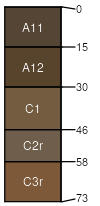
Caperton
(50%)
Low Elevation Foothills
Entic Haploxerolls
Somewhat excessively drained
Hydric: No
PAWS: 5 cm
hills / Backslope
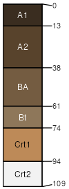
Andregg
(30%)
Low Elevation Foothills
Ultic Haploxerolls
Well drained
Hydric: No
PAWS: 9 cm
hills / Backslope
Unnamed
(10%)
Hydric: No
PAWS: NA
Unnamed
(4%)
Hydric: No
PAWS: NA
Sierra
(3%)
Hydric: No
PAWS: NA
Rock outcrop
(2%)
Hydric: No
PAWS: NA
Unnamed
(1%)
Hydric: Yes
PAWS: NA
drainageways
SSA
Scale
Published
Export
ca620
1:24,000
1975
2025-09-02