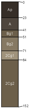
Sybil (60%)
Steep Sandy Upland Forest
Mollic Hapludalfs
Well drained
Hydric: No
PAWS: 22 cm |
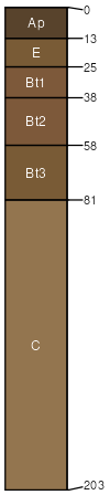
hillslopes / Summit hillslopes / Shoulder hillslopes / Backslope outwash plains
|
|
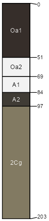
Eagleview (30%)
Steep Sandy Upland Forest
Lamellic Udipsamments
Somewhat excessively drained
Hydric: No
PAWS: 15 cm |
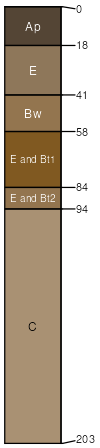
hillslopes / Summit hillslopes / Shoulder hillslopes / Backslope outwash plains
|
|
Almora (2%)
Hydric: No
PAWS: NA |
|
|
Bluffcreek (2%)
Hydric: No
PAWS: NA |
|
|
Areas with more or less slope (2%)
Hydric: No
PAWS: NA |

|
|
Forada (2%)
Hydric: Yes
PAWS: NA |
|
|
Nidaros (1%)
Hydric: Yes
PAWS: NA |
|
|
Pinelake (1%)
Hydric: Yes
PAWS: NA |
|
|