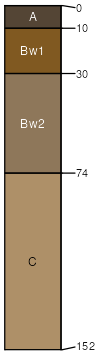
Dunnville very fine sandy loam, mottled subsoil variant, 1 to 3 percent slopes
Dunnville variant
(90%)
Loamy Uplands
Aquic Hapludolls
Somewhat poorly drained
Hydric: No
PAWS: 20 cm
stream terraces / Footslope
Alluvial land, wet
(5%)
Poorly drained
Hydric: Yes
PAWS: 20 cm
flood plains / Toeslope
Dunnville
(3%)
Loamy Upland
Typic Hapludolls
Well drained
Hydric: No
PAWS: 16 cm
stream terraces
Meehan variant
(2%)
Moist Sandy Upland
Aquic Udorthents
Somewhat poorly drained
Hydric: No
PAWS: 9 cm
stream terraces / Footslope
SSA
Scale
Published
Export
wi097
1:20,000
1972
2025-09-10