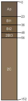
LeRoy silt loam, 6 to 12 percent slopes, eroded
LeRoy
(90%)
Loamy Upland with Carbonates
Typic Hapludalfs
Well drained
Hydric: No
PAWS: 20 cm
till plains / Shoulder
till plains / Backslope
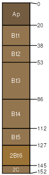
St. Charles
(6%)
Loamy and Clayey Upland
Typic Hapludalfs
Well drained
Hydric: No
PAWS: NA
till plains / Shoulder
till plains / Backslope
St. Charles
(4%)
Loamy and Clayey Upland
Typic Hapludalfs
Moderately well drained
Hydric: No
PAWS: NA
till plains / Summit
SSA
Scale
Published
Export
wi027
1:16,000
1976
2025-09-10