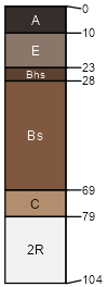
Amadon (50%)
Loamy Upland
Lithic Haplorthods
Well drained
Hydric: No
PAWS: 7 cm |

till plains / Backslope till plains / Footslope
|
|
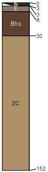
Longrie (40%)
Loamy Upland
Typic Haplorthods
Well drained
Hydric: No
PAWS: 11 cm |
|
|
Rock outcrop (5%)
Hydric: Unranked
PAWS: NA |

|
|
Battydoe (3%)
Loamy Upland
Typic Haplorthods
Well drained
Hydric: No
PAWS: 25 cm |

till plains / Summit till plains / Shoulder till plains / Backslope till plains / Footslope
|
|
Guardlake (2%)
Sandy Upland
Typic Haplorthods
Well drained
Hydric: No
PAWS: 11 cm |
outwash plains / Summit outwash plains / Shoulder outwash plains / Backslope
|
|