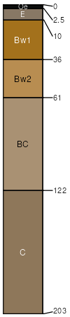
Wurtsmith loamy sand, map 22-30, 0 to 3 percent slopes
Wurtsmith
(85%)
Dry Sandy Upland Coniferous Forest
Oxyaquic Udipsamments
Moderately well drained
Hydric: No
PAWS: 15 cm
rises
lake plains
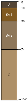
Meehan
(10%)
Moist Sandy Mixed Forest
Aquic Udipsamments
Somewhat poorly drained
Hydric: No
PAWS: 14 cm
lake plains
flats
rises
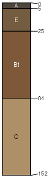
Two Inlets
(2%)
Very Dry Sandy Upland Coniferous Forest
Psammentic Hapludalfs
Excessively drained
Hydric: No
PAWS: 9 cm
beach ridges / Shoulder
beach ridges / Summit
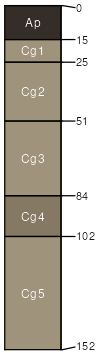
Clearriver
(2%)
Dry Sandy Upland Coniferous Forest
Aquic Udipsamments
Moderately well drained
Hydric: No
PAWS: 11 cm
beach ridges / Shoulder
beach ridges / Backslope
Cormant
(1%)
Wet Mixed Forest
Mollic Psammaquents
Poorly drained
Hydric: Yes
PAWS: 17 cm
flats
swales
lake plains
SSA
Scale
Published
Export
mn135
1:24,000
1999
2025-09-10