Burford (50%)
Loamy Upland
Typic Haplustepts
Well drained
Hydric: No
PAWS: 21 cm |
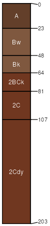
hills / Summit hillslopes / Shoulder
|
|
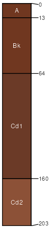
Spikebox (40%)
Shallow Upland
Typic Haplustepts
Well drained
Hydric: No
PAWS: 5 cm |

hillslopes / Summit hillslopes / Shoulder hillslopes / Backslope
|
|
Gotebo (7%)
Loamy Upland
Typic Haplustepts
Well drained
Hydric: No
PAWS: NA |

hills hillslopes / Backslope
|
|
Vernon (3%)
Red Clay (North)
Typic Haplustepts
Well drained
Hydric: No
PAWS: NA |
hillslopes / Shoulder hills
|
|