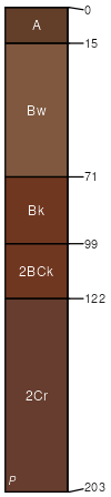
Burford silt loam, 1 to 3 percent slopes
Burford
(95%)
Loamy Upland
Typic Haplustepts
Well drained
Hydric: No
PAWS: 26 cm
hills / Summit
hillslopes / Shoulder
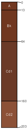
Vernon
(5%)
Red Clay (North)
Typic Haplustepts
Well drained
Hydric: No
PAWS: NA
hillslopes / Shoulder
hills
SSA
Scale
Published
Export
ok151
1:24,000
1995
2025-09-02