Burford-Vernon complex, 5 to 12 percent slopes
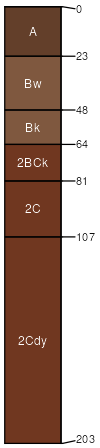
Burford
(65%)
Loamy Upland
Typic Haplustepts
Well drained
Hydric: No
PAWS: 21 cm
hills / Summit
hillslopes / Shoulder
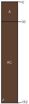
Vernon
(25%)
Shallow Clay 19-26 PZ
Typic Haplustepts
Well drained
Hydric: No
PAWS: 14 cm
hillslopes / Backslope
hillslopes / Footslope
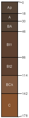
St. Paul
(5%)
Loamy Upland
Pachic Argiustolls
Hydric: No
PAWS: NA
paleoterraces
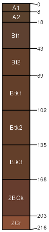
Tillman
(3%)
Clay Loam 23-30 PZ
Vertic Paleustolls
Hydric: No
PAWS: NA
paleoterraces
Rock outcrop
(2%)
Hydric: No
PAWS: NA
ridges / Summit
ridges / Shoulder
ridges / Backslope
SSA
Scale
Published
Export
ok093
1:24,000
1965
2025-08-29