Shilder-Westsum complex, 5 to 20 percent slopes
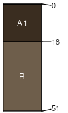
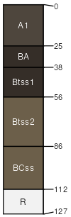
Shidler
(55%)
Shallow Hills
Lithic Haplustolls
Well drained
Hydric: No
PAWS: 5 cm
hillslopes / Backslope
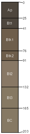
Westsum
(30%)
Claypan Upland (North)
Udertic Argiustolls
Well drained
Hydric: No
PAWS: 36 cm
hillslopes / Backslope
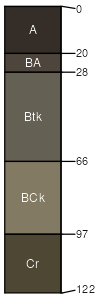
Foraker
(5%)
Clay Hills
Udertic Argiustolls
Moderately well drained
Hydric: No
PAWS: 11 cm
hillslopes / Backslope
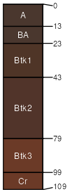
Grainola
(5%)
Claypan Upland (North)
Udertic Haplustalfs
Well drained
Hydric: No
PAWS: 13 cm
hillslopes / Backslope
Apperson
(5%)
Clayey Upland
Aquic Hapluderts
Somewhat poorly drained
Hydric: No
PAWS: 20 cm
hillslopes / Backslope
SSA
Scale
Published
Export
ok071
1:24,000
1965
2025-08-29