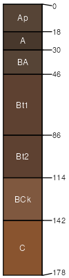
Mansic (45%)
Limy Upland 16-24 PZ
Aridic Calciustolls
Well drained
Hydric: No
PAWS: 26 cm |
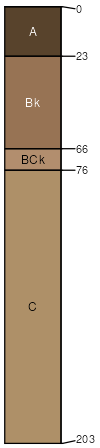
hills hillslopes / Backslope
|
|
Wellsford (40%)
Red Shale
Typic Haplustepts
Well drained
Hydric: No
PAWS: 3 cm |
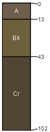
hills hillslopes / Backslope
|
|
Quinlan (5%)
Shallow Upland
Typic Haplustepts
Well drained
Hydric: No
PAWS: 4 cm |
hills hillslopes / Backslope
|
|
Dill (5%)
Sandy Loam 23-31 PZ
Typic Haplustepts
Well drained
Hydric: No
PAWS: 9 cm |
hills hillslopes / Backslope
|
|
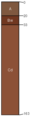
St. Paul (3%)
Loamy Upland
Pachic Argiustolls
Well drained
Hydric: No
PAWS: 39 cm |
|
|
Rock outcrop (2%)
Hydric: No
PAWS: NA |

|
|