Adit, moderately impacted, stony-Rock outcrop complex, 4 to 15 percent slopes
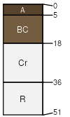
Adit
(60%)
Shallow Shrubland Group
Aridic Lithic Ustorthents
Somewhat excessively drained
Hydric:
PAWS: 1 cm
hills
Rock outcrop
(20%)
Hydric:
PAWS: NA
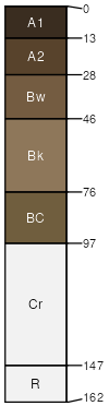
Modess
(10%)
Upland Grassland Group
Aridic Haplustolls
Well drained
Hydric:
PAWS: 12 cm
hills
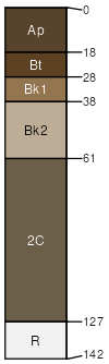
Nuley
(5%)
Upland Grassland Group
Calcidic Argiustolls
Well drained
Hydric:
PAWS: 13 cm
hills
Dumps
(4%)
Hydric:
PAWS: NA
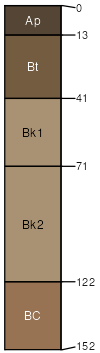
Varney
(1%)
Upland Grassland Group
Calcidic Argiustolls
Well drained
Hydric:
PAWS: 15 cm
hills / Toeslope
SSA
Scale
Published
Export
mt670
1:24,000
2007
2025-09-03