Rockerjohn-Valleyflat complex, 4 to 20 percent slopes, very stony, moderately impacted
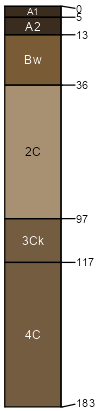
Rockerjohn
(50%)
Upland Sagebrush Shrubland
Aridic Haplustolls
Well drained
Hydric:
PAWS: 15 cm
hills / Backslope
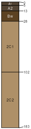
Valleyflat
(35%)
Upland Sagebrush Shrubland
Aridic Haplustolls
Well drained
Hydric:
PAWS: 8 cm
swales
hills / Footslope
Anaconda
(10%)
Upland Grassland Group
Aridic Haplustolls
Well drained
Hydric:
PAWS: 17 cm
hills / Toeslope
Valleyflat
(5%)
Upland Grassland Group
Aridic Haplustolls
Well drained
Hydric:
PAWS: 8 cm
hills / Toeslope
SSA
Scale
Published
Export
mt670
1:24,000
2007
2025-09-03