Samday-Grummit complex, 2 to 30 percent slopes
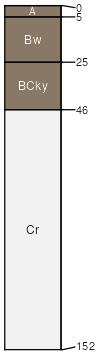
Samday
(41%)
Shallow Clay
Ustic Torriorthents
Well drained
Hydric: No
PAWS: 7 cm
ridges
hills
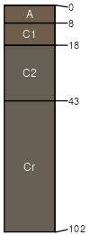
Grummit
(39%)
Shallow Clay
Ustic Torriorthents
Well drained
Hydric: No
PAWS: 5 cm
ridges
hills
Maggin
(10%)
Hydric: No
PAWS: NA
Rock outcrop
(10%)
Hydric: No
PAWS: NA
SSA
Scale
Published
Export
wy045
1:24,000
1984
2025-09-04