Collier-Lapine-Onionpie complex, 2 to 15 percent slopes
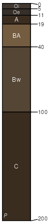
Collier
(35%)
Pumice Plateau, Volcanic Uplands (Ponderosa Pine / Antelope bitterbrush) 18-25 PZ
Xeric Vitricryands
Somewhat excessively drained
Hydric: No
PAWS: 17 cm
volcanic fields
dunes / Summit
flows / Summit
Lapine
(31%)
Pumice Plateau, Volcanic Uplands (Ponderosa Pine / Antelope bitterbrush) 18-25 PZ
Xeric Vitricryands
Excessively drained
Hydric: No
PAWS: 16 cm
volcanic fields / Summit
volcanic fields / Shoulder
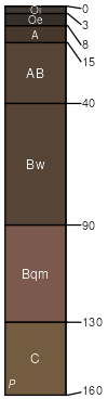
Onionpie
(29%)
Pumice Plateau, Volcanic Uplands (Ponderosa Pine / Antelope bitterbrush) 18-25 PZ
Typic Duricryands
Somewhat excessively drained
Hydric: No
PAWS: 14 cm
volcanic cones / Footslope
volcanic cones / Toeslope
hills / Footslope
hills / Toeslope
volcanic fields
Collier
(5%)
Pumice Plateau, Volcanic Uplands (Ponderosa Pine / Antelope bitterbrush) 18-25 PZ
Xeric Vitricryands
Somewhat excessively drained
Hydric: No
PAWS: 17 cm
hills
dunes / Backslope
flows / Backslope
SSA
Scale
Published
Export
or683
1:24,000
2025
2025-09-10