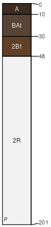
Maset-Hawkslake complex, 2 to 12 percent slopes
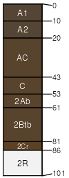
Maset
(50%)
Oregon East Cascades, Outwash Plains and Volcanic Uplands (Ponderosa pine / Antelope bitterbrush / Idaho Fescue) 14-18 PZ
Alfic Vitrixerands
Well drained
Hydric: No
PAWS: 9 cm
dip slopes / Backslope
rock pediments / Summit
low hills / Backslope
low hills / Footslope
low hills / Toeslope
volcanic fields
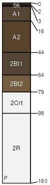
Hawkslake
(35%)
Oregon East Cascades, Outwash Plains and Volcanic Uplands (Ponderosa pine / Antelope bitterbrush / Idaho Fescue) 14-18 PZ
Alfic Vitrixerands
Well drained
Hydric: No
PAWS: 20 cm
hills / Backslope
hills / Footslope
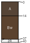
Raycreek
(6%)
JUNIPER DRY PINE 14-16 PZ
Vitrandic Argixerolls
Well drained
Hydric: No
PAWS: 12 cm
lava flows / Footslope
hills
Vitrassun
(3%)
JUNIPER DRY PINE 14-16 PZ
Lithic Haploxerolls
Well drained
Hydric: No
PAWS: 6 cm
rock pediments / Summit
lava flows
scarps / Backslope
Woodenpole
(2%)
JUNIPER DRY PINE 14-16 PZ
Alfic Humic Vitrixerands
Well drained
Hydric: No
PAWS: 8 cm
volcanic fields
deflation basins / Toeslope
Teleflat
(2%)
Meadow Swale 14-26 PZ
Aquandic Cryaquolls
Poorly drained
Hydric: Yes
PAWS: 28 cm
flood plains
Merlin
(2%)
STONY CLAYPAN 14-20 PZ
Lithic Argixerolls
Well drained
Hydric: No
PAWS: 5 cm
lava flows
deflation basins / Shoulder
SSA
Scale
Published
Export
or683
1:24,000
2025
2025-09-10