Vitrandic Durixerolls-Hawkslake complex, 2 to 12 percent slopes
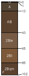
Vitrandic Durixerolls
(65%)
Oregon East Cascades, Outwash Plains and Volcanic Uplands (Ponderosa pine / Antelope bitterbrush / Idaho Fescue) 14-18 PZ
Vitrandic Durixerolls
Well drained
Hydric: No
PAWS: 7 cm
volcanic fields
hills / Footslope
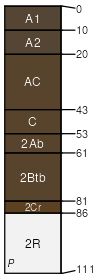
Hawkslake
(20%)
Oregon East Cascades, Outwash Plains and Volcanic Uplands (Ponderosa pine / Antelope bitterbrush / Idaho Fescue) 14-18 PZ
Alfic Vitrixerands
Well drained
Hydric: No
PAWS: 20 cm
hills / Backslope
volcanic fields
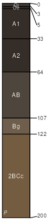
Maset
(10%)
Oregon East Cascades, Outwash Plains and Volcanic Uplands (Ponderosa pine / Antelope bitterbrush / Idaho Fescue) 14-18 PZ
Alfic Vitrixerands
Well drained
Hydric: No
PAWS: 9 cm
rock pediments / Summit
low hills / Backslope
low hills / Footslope
low hills / Toeslope
volcanic fields
Spragueriver
(2%)
Dry Pumice Meadow 14-26 PZ
Aquandic Cryaquolls
Poorly drained
Hydric: Yes
PAWS: 31 cm
flood plains
Bigtop
(2%)
Dry Pumice Meadow 14-26 PZ
Aquandic Cryaquolls
Poorly drained
Hydric: No
PAWS: 14 cm
depressions / Footslope
depressions / Toeslope
drainageways
lava flows
Hallet
(1%)
Dry Pumice Meadow 14-26 PZ
Vitrandic Haplocryolls
Somewhat poorly drained
Hydric: No
PAWS: 20 cm
alluvial fans / Footslope
alluvial fans / Toeslope
drainageways
SSA
Scale
Published
Export
or683
1:24,000
2025
2025-09-10