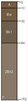
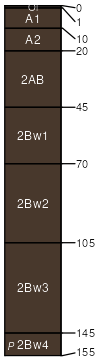
Xeric Haplocalcids, Typic Calcixerolls, and Typic Argixerolls soils, 1 to 29 percent slopes

Xeric Haplocalcids family (35%)
SHALLOW CALCAREOUS SLOPE 14+ P.Z.
Xeric Haplocalcids
Well drained
Hydric: No
PAWS: 12 cm
stream terraces
Typic Calcixerolls family (30%)
Shallow to Loamy, Calcareous 15-19 Inch Precipitation Zone Lost River Mountains
Typic Calcixerolls
Well drained
Hydric: No
PAWS: 11 cm
stream terraces
alluvial fans
fan remnants
Typic Argixerolls family (15%)
Loamy 15-19 PZ Frigid Challis Volcanics
Typic Argixerolls
Well drained
Hydric: No
PAWS: 21 cm
alluvial fans
mountain slopes
Cumulic Cryaquolls family (5%)
Riparian Wet Meadow Challis Volcanics
Cumulic Cryaquolls
Poorly drained
Hydric: Yes
PAWS: 18 cm
flood plains
Pachic Argixerolls family (5%)
MOUNTAIN POORLY DRAINED BOTTOM ARCAV3-DAFRF/FEID
Pachic Argixerolls
Well drained
Hydric: No
PAWS: 27 cm
drainageways
swales
Vitrandic Haploxerolls family (5%)
Ashy Cold Woodland Group
Vitrandic Haploxerolls
Well drained
Hydric: No
PAWS: 29 cm
stream terraces
Typic Haploxerolls family (5%)
Steep Loamy 15-19 Inch Precipitation Zone Lost River Mountains
Typic Haploxerolls
Well drained
Hydric: No
PAWS: 13 cm
mountain slopes
SSAScalePublishedExport
id7001:24,0002025-08-27