Teton (40%)
Upland Shrubland Group
Typic Cryoborolls
Well drained
Hydric: No
PAWS: 11 cm |
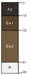
hills / Shoulder hills / Backslope
|
|
Mayflower (30%)
Upland Shrubland Group
Argic Pachic Cryoborolls
Well drained
Hydric: No
PAWS: 17 cm |
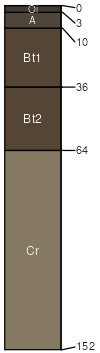
mountain slopes / Shoulder mountain slopes / Backslope
|
|
Duncom (25%)
Shallow Shrubland Group
Lithic Cryoborolls
Well drained
Hydric: No
PAWS: 5 cm |
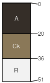
mountain slopes / Summit mountain slopes / Shoulder
|
|
Rock outcrop (5%)
Hydric: No
PAWS: NA |

|
|