Sproulish-Canoecreek-Redwohly complex, 30 to 50 percent slopes
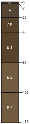
Sproulish
(50%)
Fog-influenced, low elevation slopes and footslopes
Typic Dystrustepts
Well drained
Hydric: No
PAWS: 33 cm
mountain slopes / Backslope
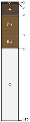
Canoecreek
(20%)
Dry, steep mountain slopes
Andic Haplustepts
Well drained
Hydric: No
PAWS: 13 cm
mountain slopes / Shoulder
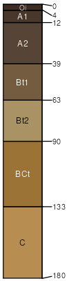
Redwohly
(15%)
Fog-influenced, low elevation mountain slopes
Ultic Haplustalfs
Well drained
Hydric: No
PAWS: 9 cm
mountain slopes / Shoulder
mountain slopes / Backslope
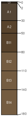
Crazycoyote
(5%)
Dry, steep mountain slopes
Typic Humustepts
Well drained
Hydric: No
PAWS: 22 cm
mountain slopes / Backslope
Canoecreek
(4%)
Dry, steep mountain slopes
Andic Haplustepts
Well drained
Hydric: No
PAWS: 20 cm
mountain slopes / Backslope
Caperidge
(4%)
Dry, steep mountain slopes
Typic Humustepts
Well drained
Hydric: No
PAWS: 19 cm
ridges / Summit
ridges / Shoulder
Rock outcrop
(2%)
Hydric: No
PAWS: NA
mountain slopes / Backslope
SSA
Scale
Published
Export
ca601
1:24,000
2011
2025-09-03