Bullrey-Libeg-Foureyes, families, complex, 20 to 60 percent slopes
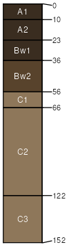
Bullrey family
(45%)
Droughty Steep 19-24 PZ Cryic Beaverhead Mountains
Pachic Haplocryolls
Well drained
Hydric: No
PAWS: 21 cm
mountain slopes
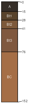
Libeg family
(30%)
Droughty Steep 15-19 PZ Cryic Beaverhead Mountains
Ustic Argicryolls
Well drained
Hydric: No
PAWS: 16 cm
mountain slopes
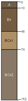
Foureyes family
(20%)
Limy Grassland Group
Ustic Calcicryepts
Well drained
Hydric: No
PAWS: 7 cm
mountain slopes
Rubble land
(5%)
Hydric: No
PAWS: NA
SSA
Scale
Published
Export
id720
1:24,000
2025-08-27