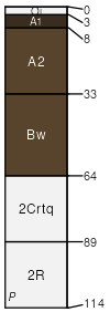
Fryrear-Wanoga-Rock outcrop complex, moist, 15 to 50 percent slopes
Fryrear
(40%)
Oregon East Cascades, Outwash Plains and Volcanic Uplands (Ponderosa pine / Antelope bitterbrush / Idaho Fescue) 14-18 PZ
Humic Vitrixerands
Well drained
Hydric: No
PAWS: 6 cm
canyon walls / Backslope
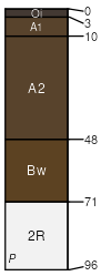
Wanoga
(30%)
Oregon East Cascades, Outwash Plains and Volcanic Uplands (Ponderosa pine / Greenleaf manzanita) 16-20 PZ
Humic Vitrixerands
Well drained
Hydric: No
PAWS: 11 cm
canyon walls / Backslope
Rock outcrop
(20%)
Hydric: No
PAWS: NA
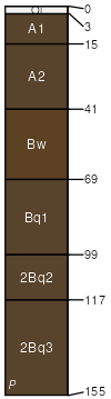
Laidlaw
(5%)
Oregon East Cascades, Outwash Plains and Volcanic Uplands (Ponderosa pine / Greenleaf manzanita) 16-20 PZ
Humic Vitrixerands
Well drained
Hydric: No
PAWS: 27 cm
swales / Footslope
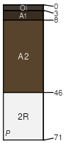
Henkle
(5%)
Oregon East Cascades, Outwash Plains and Volcanic Uplands (Ponderosa pine / Antelope bitterbrush / Idaho Fescue) 14-18 PZ
Lithic Vitrixerands
Somewhat excessively drained
Hydric: No
PAWS: 5 cm
canyon walls / Summit
canyon walls / Shoulder
SSA
Scale
Published
Export
or605
1:24,000
2025-09-09