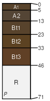
Bellenmine-Cowgil-Birchcreek association
Bellenmine
(40%)
Shallow Gravelly Mountains 12-16 PZ
Lithic Argixerolls
Well drained
Hydric: No
PAWS: 4 cm
hillslopes / Backslope
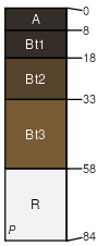
Cowgil
(30%)
LOAMY 8-10 P.Z.
Xeric Haplargids
Well drained
Hydric: No
PAWS: 9 cm
hillslopes / Backslope
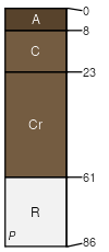
Birchcreek
(15%)
GRAVELLY LOAM 12-14 P.Z.
Typic Argixerolls
Well drained
Hydric: No
PAWS: 6 cm
hillslopes / Footslope
Eightmile
(6%)
PIMO-JUOS/ARTRW/PSSPS-ACHY Not A Valid Forest ESC
Xeric Torriorthents
Well drained
Hydric: No
PAWS: 2 cm
hillslopes / Shoulder
Cleavage
(6%)
MOUNTAIN RIDGE 14+ P.Z.
Aridic Lithic Argixerolls
Well drained
Hydric: No
PAWS: 4 cm
hillslopes / Summit
Sevenmile
(3%)
LOAMY BOTTOM 10-14 P.Z.
Vitritorrandic Haploxerolls
Well drained
Hydric: No
PAWS: 21 cm
stream terraces / Toeslope
SSA
Scale
Published
Export
nv782
1:24,000
2025
2025-09-02