Ashfork-Dogpaws-Cross complex, 0 to 6 percent slopes
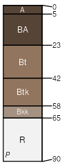
Ashfork
(35%)
Clay Loam Upland 14-18 p.z.
Calcidic Argiustolls
Well drained
Hydric: No
PAWS: 9 cm
lava flows / Shoulder
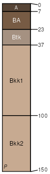
Dogpaws
(30%)
Clay Loam Upland 14-18 p.z.
Calcidic Haplustalfs
Well drained
Hydric: No
PAWS: 26 cm
lava plains / Toeslope
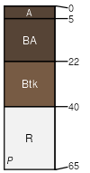
Cross
(25%)
Clay Loam Upland 14-18 p.z.
Aridic Lithic Argiustolls
Well drained
Hydric: No
PAWS: 5 cm
lava flows / Summit
Thunderbird
(5%)
Hydric: No
PAWS: NA
Lava flows
(5%)
Hydric: No
PAWS: NA
SSA
Scale
Published
Export
az631
1:24,000
1980
2025-08-26