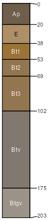
Clarendon sandy loam, 0 to 2 percent slopes
Clarendon
(95%)
Summits, Loamy and Clayey, Seasonally Wet
Plinthaquic Paleudults
Moderately well drained
Hydric: No
PAWS: 17 cm
hills / Summit
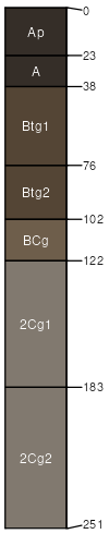
Paxville
(1%)
Upland Depressions, Flats, and Carolina Bays
Typic Umbraquults
Very poorly drained
Hydric: Yes
PAWS: 23 cm
depressions / Toeslope
SSA
Scale
Published
Export
al067
1:20,000
1986
2025-09-09