Foreleft-Bronec, very stony-Geohrock, stony complex, 20 to 50 percent slopes
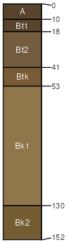
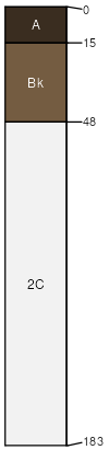
Foreleft
(30%)
Loamy (Ly) Absaroka Lower Foothills
Aridic Haplustalfs
Well drained
Hydric: No
PAWS: 29 cm
complex landslides
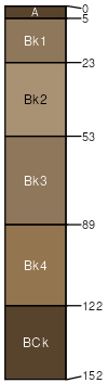
Bronec
(25%)
Cobbly Upland (CoU) Absaroka Lower Foothills
Aridic Calciustepts
Well drained
Hydric: No
PAWS: 12 cm
complex landslides
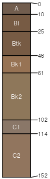
Geohrock
(20%)
Cobbly Upland (CoU) Absaroka Lower Foothills
Aridic Haplustalfs
Well drained
Hydric: No
PAWS: 20 cm
complex landslides
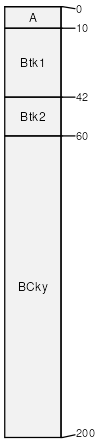
Amalia-like
(10%)
Stony Upland (StU) Absaroka Lower Foothills
Calcidic Haplustalfs
Well drained
Hydric: No
PAWS: 14 cm
complex landslides
Kremlin
(10%)
Limy Upland (LiU) Absaroka Lower Foothills
Aridic Haplustolls
Well drained
Hydric: No
PAWS: 26 cm
complex landslides
Utica
(5%)
Gravelly (Gr) Absaroka Upper Foothills
Typic Calciustolls
Well drained
Hydric: No
PAWS: 4 cm
complex landslides
SSA
Scale
Published
Export
wy656
1:24,000
2008
2025-09-04